Thursday, September 9, 2010

Bryce

Ethan walking along the wooded area. Both kids have their own backpack with water and snacks. It is really nice that we do not have to carry it all!

There were a few small archways to walk through.


(I am having technical difficulties tonight getting the pictures to upload. After 25 minutes I finally closed it and tried with two pictures. It seems three pictures usually takes 10 - 15 minutes, but not tonight.)

Back to Bryce Canyon National Park


At Bryce we hiked the Queens/Navajo Combination Loop. In the visitors guide it is called "World's best 3-mile hike!". For me this hike tied for best hike of our trip (with The Narrows at Zion). You leave from Sunrise Point and see the Queens Garden. We cut up through Wall Street which recently opened after being closed for 18 months due to a rock slide and end up at Sunset Point. As you walk along the trail you see shapes of things in the hoodoos. Thor's Hammer, E.T.'s finger, Queen Victoria to name a few. It was lightly sprinkling on us, of course, but it cleared soon enough. It was interesting walking through the hoodoos and then wooded areas. After the hike we ate our lunch in the picnic area at Sunset Point.

Wednesday, September 8, 2010

Capitol Reef National Park

Fruita Schoolhouse

Scenic road at Capitol Reef.

Petroglyphs! (look in the middle of the picture for drawings)

We thought the school house was put in a crazy location! It looks like the rocks behind it will hit the school. The scenic road had a few boulders in the road due to the flash flood they had the day before. At the Visitor's Center while the kids were getting their fifth Jr. Ranger Badge they announced the road had been cleared and was now open. Lucky for us! You can see from the picture the dirt still on the road from the day before. The Petroglyphs were really neat! You can see part of them slide off in a rock slide in prior years. It looks like people holding hands.

Backtracking to Capitol Reef

Tired. I will explain below.

Road to Capitol Reef.

Barn at Capitol Reef.

We planned on getting up early to see the sunrise on the Hoodoos. Supposedly they light up like birthday candles. Oddly Allen woke up and realized the alarm clock did not wake us up, but we had just enough time to get to the vista point and see the sunrise. We made a mad dash to see the sunrise. I said supposedly light up like candles because it ended up being overcast and when the sun did finally come out thirty minutes later there wasn't the spectacular glow we were looking for. Oh well. We were up early and going to Capitol Reef! The drive to Capitol Reef was one of the most diverse. They call it a "scenic route" for a reason. As I sort through the pictures I will highlight some of the areas we drove through. The kids and I were pooped out and slept in the car part of the way. Capitol Reef has many fruit orchards and a bakery that sells goodies.

Bryce Canyon National Park

Road to Bryce Canyon National Park.

Hoodoos at Bryce.

Sunset at our campsite.
The first day we were at Bryce we went to a Ranger lead walk along the rim of the canyon. Ethan raised his hand to answer a question (what is a fast animal that lives in the park) and said "snake"... Hmmm. Usually he gets these right (at Mesa he was on a roll!). We found out the Ponderosa Pine bark smells like butterscotch or vanilla. We also found out that we missed a really neat National Park on our way to Bryce. We decided to stay an extra night at Bryce and take a day trip to Capitol Reef National Park.

Canyonlands National Park

View through arch in Canyonlands.

Ethan looking through.

I think this was Jr. Ranger Badge number four.

Arches and Canyonlands are near each other and Moab. We drove through both of them in one day but did not do any major hiking. It was raining off and on, therefore flash floods were likely on the trails. This arch was not a far hike from the road. It is our favorite arch that we saw at any of the National Parks. It is smaller than any of the other arches we saw but something about it made it special. From here we headed to Bryce Canyon National Park. We stopped in Richland around eleven p.m. for the night.

Still at Arches

South Window Arch.

At Park Avenue Viewpoint and Trailhead.

Arches National Park

North Window Arch is behind them.
Behind me is the South Arch.

Trail to South Window Arch.

Ethan looking through the North Window Arch.

Again it was raining off and on while we were here. Besides the North and South Window arches we took a short hike to see the Delicate Arch. It is the thinnest arch and at some point will break. I will look for the pictures of that one. We told the kids when they bring their kids it might not be an arch. They can tell their kids about how when they came it was an arch...


Tuesday, September 7, 2010

Moab, Utah

Arch near Moab, Utah.


We stopped for the night in Moab, Utah. It was supposed to rain really hard that night so we stayed in a small cabin. We washed clothes and went swimming that night. The next morning it started to rain as we were packing up the van. From here we headed to Arches National Park and Canyonlands National Park.

More - Cliff Palace

Painting on the upper floor at the Cliff Palace. You stick your head in the lower floor door and look up.


In the upper area they stored their crops.
Mesa Verde was one of my favorite places I went to as a kid and it is one of Rachael's favorites. It is adventurous to get to these dwellings and the stories of the people who lived there are interesting.

Balcony House, Mesa Verde National Park

Kiva, a ceremonial pit. The hole represents where they came from, below the earth's surface. Ancestors still come to perform rituals. There was a feather on the bottom of this Kiva from one such ceremony recently performed.

There was a BIG ladder to get to this one.

There was a tiny tunnel to leave this one too! With my backpack on I did not make it through. This is Ethan going through. I had to toss the pack through to get out. In the middle of the tunnel you can stand up. This is a tunnel the natives used.

Cliff Palace at Mesa Verde

Ladder up to Cliff Palace.

Cliff Palace family picture.

Steps leaving the Cliff Palace.

We went to both the Cliff Palace and Balcony House. Both had fun hikes to and from them. Both had similarities yet differences that made them unique. The Balcony House hike was a bit more challenging, but both kids did great. If there were not fences on some of these areas we would not of done them with the kids. The Ranger said that they found crutches indicating the natives at times might of needed railings too...

Mexican Hat and Mesa Verde National Park

Mexican Hat.

Mesa Verde, Cliff Palace. This is from a viewpoint above. This is one of the largest dwellings in the area and thought to be more of a Community Center. This is where most of the grain was stored from the area.

The wood is original and probably hung out farther to make balconies. There are no "windows" here. They are all doors. The people who lived there were Rachael's height. The stone work at the beginning was rough but as they became skilled they took the time to shape the rocks to blocks.

More Monument Valley


Coolest spot we slept...

This is the wood ceiling.

The inside.

The outside.
We slept in a Hogan, a Navajo traditional house. Monument Valley has a male, female and sweat house hogan. The shape classifies it as male or female, I do not need to explain any further. They are a wood structure with mud/clay on the outside. We put a tarp down on the dirt floor to lay our sleeping bags down. The guy told us to be watchful of black widows, which Ethan did find one and decided to sleep on the other side of the Hogan. Allen did take care of the spider and did not tell Rachael until the morning that there was a spider on her side. She said she knew, but was too tired to care.

Monument Valley

Monument Valley has a dirt road that takes you around all of these amazing rock formations. It is hard to pick which ones to post. I will go back during slower months and post some more.

This is from the top, looking into the valley. You can see the dirt road below us. It is a steep drop behind us.

Some of the formations we drove by in Monument Valley. One thing we did not realize was most of Monument Valley is in Arizona but you drive up to Utah to enter it. Ethan kept asking when we were going to be in Utah. Once we reached Utah we were there for a few short minutes before heading south again into Arizona.

From Painted Forest to Monument Valley

The funny thing about this photo is that we are camping, yet still watching a cowboy movie on the laptop while eating dinner. We brought many DVD's and only watched three of them. Me forgetting them in our Vegas motel room is a story for later...

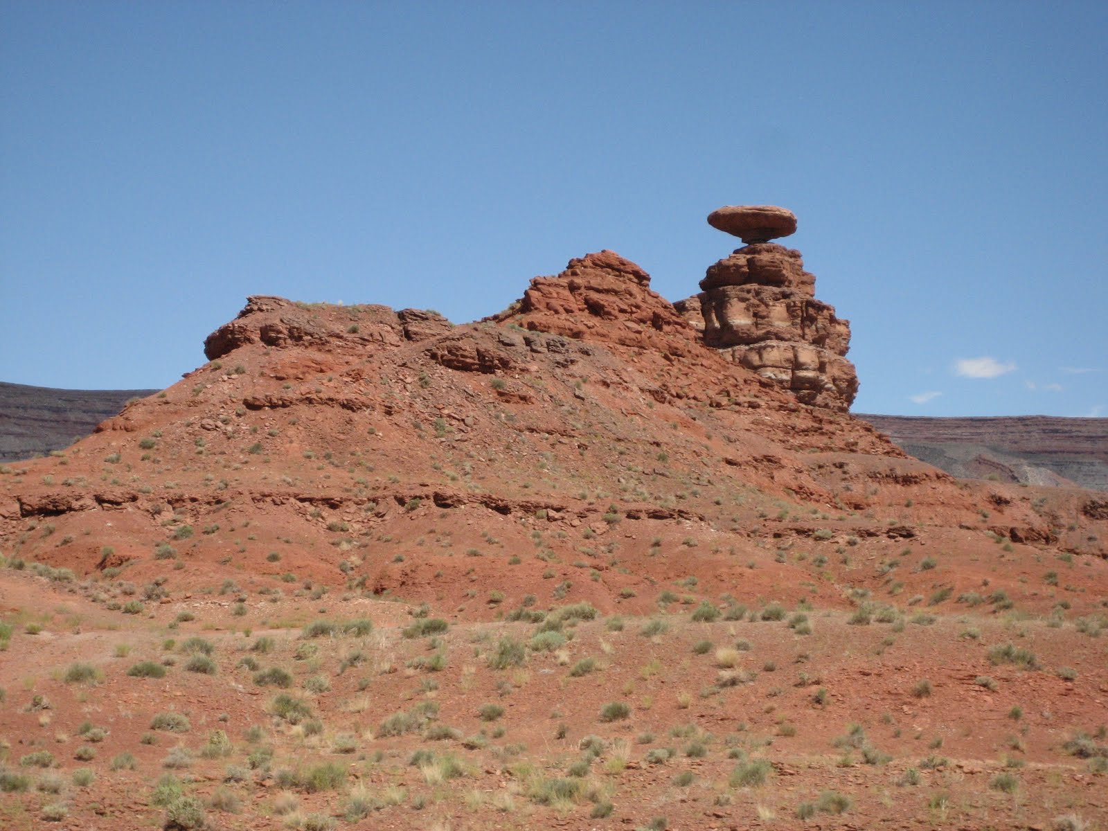
This is on the road that was washed out.

We hit more rain as we drove from the Painted Desert to Monument Valley. We noticed a roadwork sign and the traffic was stopped. We waited, waited and waited. After thirty minutes we saw someone on an ATV coming from the other direction. We asked him how long the hold up would be. He said it would be awhile as the road is washed out. There was a sign a little up the road warning of flash floods... When we turned around to take another route we could see a large portion of the road ahead was a flowing river. Good thing we had maps in the car and was able to find another route.

Petrified Forest and Painted Desert

Behind the Visitor's Center is a short hike through some of the petrified wood. This area was once a swampy forest with very tall trees and dinosaurs. Hard to believe on this hot day...

Picture taken along the scenic route through the Petrified Forest. We have twenty or thirty pictures of this area. I will post more at another time. They all kind of look alike...

This is from a scenic viewpoint looking at the Painted Desert. Truly beautiful. I forgot to mention early that the Meteor Crater had flying ants. Some of the Painted Desert viewpoints had the flying ants too. As long as we calmly took our pictures and did not bother the mounds we were okay. The huge crows were funny too. They would stand on the side of the hill and watch us.

Meteor Crater Arizona

Posing with the largest fragment from the meteorite.

This is the worlds best preserved site of a meteorite impact! The crater itself is about a mile wide.

Here is the Apollo Test Capsule!
I do not have pictures of it, but the rain followed us here too! After we got some cool pictures of the crater we went inside the museum to look around. After we saw the video we came out and it was pouring rain! We decided to spend the night in a motel and head out to the Painted Desert and Petrified Forest the next morning.